Tuesday 15 September 2015

Sept 2015 Update

Residents from Island View Beach and McRae Beach had a meeting to discuss the issue and how it can be addressed. We decided the best approach was to get a copy of the permit to allow the culverts and then see if the authority would send an enforcement officer out to the site as we saw quite a few infractions vs the permit granted and had had letters from 3 neighbors who are loosing land to erosion and or negative impact to lakefront property.
A representative from the authority and 3 residents met on Island View Beach and we had a great meeting. The authority received the registered letter we sent requesting the meeting so they went to the farm in question prior with 2 officers from the MOE and saw NO problems at all so all 3 said "whats the problem"? That's how the meeting started. This was expected so I produced a video taken in June 2015 showing clearly sediment flowing from farm into creek and flowing down the creek out into the lake. Officer was shocked and replayed the video multiple times. I produced the 3 letters and suggested we visit each complaint.
We walked the yard of one resident where 2 inflows from farm have been cut into the creek and this happens to be where the creek makes a 90 degree turn to the west. One inflows drains north and the other 10 yards from it drains west so when we have a major rain event or high water it's creating a whirlpool eating away the banks of the creek which is why he is loosing property. Officer noticed this as well and took some pictures. He stated maybe a environmental impact study should have been done before permit was granted. We also showed a fish dam there which was installed years ago by an environmental group but banks collapsing into creek and weed growth the fish population is almost non existent.
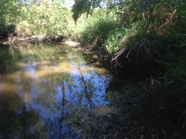
Next we went to where the video showed sediment entering the creek but with the water table down 14" all that showed was a mud bank where the rocks are and I stated when a major rain event happens the rocks will be useless as the water will wash the bank away below the rocks. Also stated directly opposite inflow land in private park being eroded due to current. He said he will look and compare satellite photos so see amount of changes on creek banks. The question why "wouldn't farm owner drain into his attached wet land acreage on north side of property?". Reply was he would have had to cut multiple smaller inflows on north side so not to damage the wet lands, Hmmmmm.
Then off to the neighbour who lives on east side of river mouth. This showed the saturation of weeds and sediment building up. You can almost walk on the weeds and boats have to be now walked out of creek as sediment built up. This creek has a community marina where residents keep their boats and use the creek as a means of entering the lake. So it's having a negative effect on a watercourse and diminishing values of lakefront properties. He said the harvesting the weeds is only a band aid solution and what has to be done is dredge and remove the loose sediment and weed roots. I wonder who pays for this as 2 years ago no problems? Heavy sediment is dropping at the mouth but lighter sediment flows all the way east to McRae Beach. Over 500 meters from source and if we add loss of depth and the drop of water level in the lake residents summer enjoyment ends mid August. The neighbour 2 doors east of mouth stated his grandson use to lay on dock and watch the perch and small bass under his dock when he was 2 years old. He is now 4 and weeds plus sediment have eliminated this pleasure as no fish so explain that to a 4 year old. He also asks why can't we swim here anymore and it is explained it not nice. Private community swimming beach on east side of that neighbour is closed due to concerns of whats flowing down the creek. Some have complained that after being in the water your skin itches. Not sure if this is due to years of bad septic deposits on creek bottom now being flushed out with influx of rushing water?
Officer stated he would bring our concerns to his superiors on Tuesday Sept 7th and hopefully we will get a positive solution. Not being an expert on solutions but I can see the the banks of creek having to be restored and secured, dredging and possible re-directing the 3 inflows from farm into farmers own wet lands which are on north side of his property vs creating a negative effect on fisheries, boat navigation, property vales and health concerns in a community.
Below are a few pictures which I hope helps in understanding the concerns...

The start August 2013

The source and exposed land

Sediment entering the lake flowing west as creek mouth 60 feet to the east

June 2015

June 2015

June 2015 and this resident use to fish off his property and now complains 0 fish

One source June 2015

Just north of one source June 2015

June 2015

Weed growth at mouth

Creek bank erosion damaged by whirlpool event


Low water in August shows exposed fresh banks of creek and once water comes up with whirlpool
event more sediment into creek and lake

Bank collapsing on private property by inflow

Banks washed away and trees falling into creek.
One neighbour actually had to cut a tree that blocked the creek to avoid flooding

Facing one inflow and in foreground bank has collapsed into creek

Bank collapsed on private property

Inflow where creeks makes the 90 degree turn showing fish dam in foreground

Bank collapsing by fish dam due to current from inflow

Looking north from 1st inflow on south side of creek

More erosion so more loose sediment waiting for high water 2016

Banks of creek near 2 inflows

New weed growth on left side is where bank collapsed from private property as directly opposite one inflow

This shot is looking west from creek showing dry fish dam as water level way down (Sept)
but in spring water rushes over and fish did use the ladder to spawn

From fish dam facing inflow so when high water rushes this creates a whirlpool eating banks away


Bank eroded away and again fresh sediment waiting for high water and off to the lake it goes

Another property showing bank collapsed right where whirlpool occurs

Same as previous


Private Park beach closed for kids


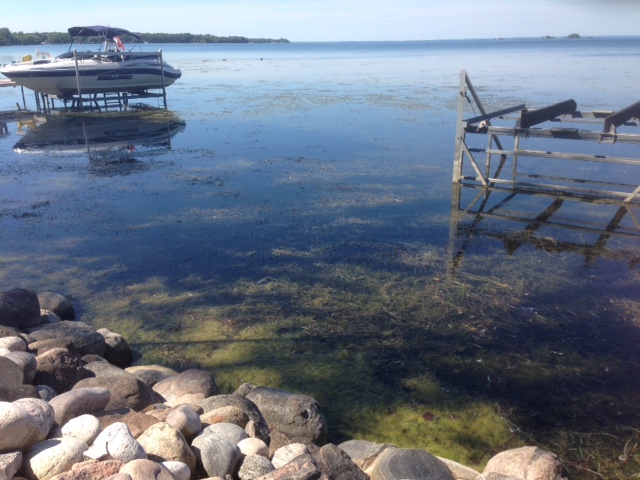
Weed Growth and empty boat left

Weed growth and this resident uses waders to enter water to push his boat out.
He complains about itching when no waders and his son not allowed to swim here.

Thursday 6 August 2015

2014 Winter Thaw

As a resident here and know the high water that this creek has during the thaw period I ventured up to take a look. Seeing the conditions I took a couple of shots so I could compare to the summer outflow picture. See below for comparison...


The above shows how much the ice and water is above the stone outflow. Also note the tint in the water of the creek. Where I was standing taking these shots is now being eroded due to the current being created. It's a private park and also the neighbor directly on the creek has concerns with eroding bank at the edge of her property.

Monday 27 July 2015

Spring 2015

Spring 2015 brings me to the next series of pictures. Clarity in creek is 0 (4' deep) and lakefront is 0 (2' deep). Strong silt presence as well a red/brown color. So much so it formed a mud line out into the lake flowing east. I walked up to one of the sources and was able to take some shots and a short video showing sediment entering the creek. Prevailing winds here are W/NW so it carried this material east along the shoreline which bring us to McRae Beach Association.


Facing west from bridge

From beach association park where erosion is taking place
This is from another bridge closer to mouth of creek
Looking south from bridge near mouth
Looking north to mouth of creek
From bridge facing east and show mud clearly
This one of 2 areas cut into bank of creek to drain.
Clearly shows sediment entering the creek.
In the foreground is the side of park being eroded.
Closer look to above picture
A short movie
Below is the link on youtube
https://www.youtube.com/watch?v=lYPe4jrh0pQ&feature=youtu.be


A concerned resident at McRae Beach contacted me and asked is this situation is from our creek. I said I am sorry but yes it is and explained the source with pictures and the video. These residents are quite concerned as we all are about the color and the increased water flow to the creek. Not only a heavy sediment, phosphorous but years of material from bad septics laying on bottom of creek now being flushed out to the lake with the increased waterflow. These residents get their drinking water from the lake and have health concerns pumping in this water. The increased waterflow is actually creating an erosion problem along creek shoreline. One of Islandview Beach's Parks is being impacted with shoreline loss as well many bushes and trees now have roots exposed which tells me where some of the sediment is coming from as well, not all but some.

The authorities were contacted again last month and they sent out a representative right away and he did have his concerns upon seeing it as well. We are waiting for feedback from them and we were advised to file a complaint with MNR + MOE which both have been filed. Waiting for feedback from both of them as well.


Today now that I have this blog I thought I would take pictures of our vollyball area. I don't think this sediment, phosphorus what ever else was on creek bed created the weeds but it does show they are thriving on it. Islandview Beach Association contacted a weed harvester to quote removing this problem but he stated fix the source don't do a bandaid fix. This harvester is the one Georgina Township used for Cooks By as well.


Our vollyball beach


I will try to update blog with any more pictures and or info as received.

Early 2014

2014 rolls around and same issues but not with same slushy consistency more so a brown reddish color with as ton of silt entering the lake. 
This issue was a hot topic at all Islandview Beach Association meetings but all frustrated as no one knew where to turn. Lakefront homeowners are upset as it seems the weeds in the lake are thriving on this run off. Some cannot even venture into the water as weeds so thick. High taxes are being paid to live on the water and enjoy it but that pleasure has been reduced.
My neighbor purchased a new jet drive seadoo boat in 2010 when he moved up here and also installed a volley ball net in the water. As everyone knows a jet drive and weeds don't get along. I don't think he would have spent close to 50K if the growth was like this 5 years ago? Both of our families had many endless hours of enjoyment with our beachfront. Now I have grandkids and I would love to have them swim out front but cannot so we have to go to a beach area vs our waterfront. It's truly a shame.


The above 4 pictures show the weed growth on the east side of creek mouth


Late 2014/Early2015 the ice on creek was a darkish brown color which was odd and had a closer look it showed creek was frozen to ground but water flowing on top of ice was more run off from the thaw, same source.

The Start...


I thought I should create one central source for information and pictures as this situation is impacting 2 residential beach communities. Both McRae Beach Association and Islandview Beach Association have concerns and are trying to rectify it.

It was mid August 2013 when I first noticed a problem with Bernie' Creek. Driving over one of the bridges early one morning I noticed the condition of the creek. Water had the consistency of a slushy as it was saturated with liquid mud. In all my years here I have never seen these conditions so immediately stopped and took some pictures which are shown below. Once I got to the city I called the proper authorities and issued a concern. My understanding is the authority did come out and pay a visit to the parties who created  this issue. To this day I have no reply on that complaint. 
Later the same year I brought the issue up with the Town of Georgina and it was suggested I talk to Fisheries. The creek is a fish habitat and they should be notified about possible ramifications. Well I did contact and was told they would investigate. Nope no feedback yet.
What amazes me is the lack of concern for the lake, the wildlife, the people who live on this creek and the lakefront home owners.
One of 2 areas allowing drainage into creek

Size of culverts put in
This picture was taken facing east from bridge as mentioned above at 7am
This picture was taken facing west from bridge as mentioned above at 7am
Arrived back home at 3pm and mud line clearly visible out into lake

This is facing NW and note mud line flowing out and east with prevailing winds